|
|
|
Previous Issues
|
|
|
|
|
|
![Review Article]()
![eMail Article]()
![Print Article]()
|
![Susan Smith - Managing Editor]() |
The Carbon Project?s CarbonArc PRO
|
September 3 - 7, 2007 by Susan Smith
A weekly summary of recently published GIS product and company news, featured downloads, customer wins, and coming events. Brought to you by GISCafé.
Each week GISWeekly Review delivers to its readers news concerning the latest developments in the GIS industry, along with a selection of other articles that we feel you might find interesting. If we missed a story that you feel deserved to be included, please contact us! Questions? Feedback? Click here. Thank-you!
|
|
|
Welcome to GISWeekly!
GISWeekly examines select top news each week, picks out worthwhile reading from around the web, and special interest items you might not find elsewhere. This issue will feature Industry News, Top News of the Week, Acquisitions/Agreements/Alliances, Announcements, People, New Products, Around the Web and Events Calendar.
GISWeekly welcomes letters and feedback from readers, so let us know what you think. Send your comments to me at giscafe-editor@IBSystems.com
Best wishes,
Susan Smith, Managing Editor
Industry News
The Carbon Project’s CarbonArc PRO
by Susan Smith
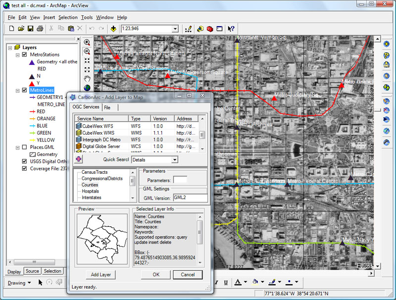
Last week The Carbon Project previewed its new product for OGC Spatial Data Infrastructure (SDI) 1.0 interoperability for ESRI’s ArcGIS 9.2 software, CarbonArc PRO. CarbonArc PRO was preceded by a smaller product to test the market about a year and a half ago, CarbonArc Lite.
SDI 1.0, a suite of standards from the OGC, is being adopted by a number of government and geospatial intelligence agencies.
“We’ve created a set of products for ArcGIS that supports that SDI 1.0 baseline,” said The Carbon Project president and CEO, Jeff Harrison. For more complicated data producers, SDI 1.0 includes familiar OGC standards such Web Map Server, GML, WFS, and additional unfamiliar things like filters and catalogs, that allow users to put together complex systems much faster and at much lower cost than they have been able to do in the past.
The Carbon Project’s flagship product, CarbonTools PRO, is an extension to the Microsoft .NET framework that supports advanced location content handling, mapping and sharing, and is the underlying toolkit CarbonArc PRO. CarbonArc PRO works only with ArcGIS 9.2 and adds a whole suite of OGC capabilities.
Historically, according to Nuke Goldstein, CTO and COO, OGC has focused on the specifications and server side implementation. “What we try to do in the Carbon Project is focus more on the end users,” Goldstein explained. “What we’re doing is unique because some specifications from OGC did not get much attention. For example, Web Feature Service – Transaction (WFS-T) is a fantastic specification and server capability, that allows end users to affect the data on the service side by creating edits, inserts, updates, etc., yet end users have not done much of this to date. CarbonArc PRO makes it possible to allow users to edit, change, update, and affect
data.”
Two main features of CarbonArc PRO for feature data: the transactions and updates just described, and an OGC specification called filter. Filters in SDI 1.0 basically allow people to plug into an online service and retrieve just the information they want. They do this by setting up spatial and other operators. Prior to this product, online services has allowed you to retrieve a lot of data, but not necessarily filtered data. With filters in CarbonArc PRO you can retrieve only the data you need, not only on your desktop, but also out there on the service.
Currently CarbonArc PRO is available only to ArcGIS 9.2 users, but The Carbon Project’s intention is to make the tools available on every Windows based desktop system.
Government agencies are now using the standards and have multiple implementations in place.
“SDI 1.0 is going to be for GIS and geospatial power users, as it is a more professional set of requirements,” said Goldstein. “Although I do think some elements will make their way to the consumer. The trick is to wrap the complexity into something that consumers can use without worrying what GML is or what WFS stands for.”
You can find the full GISCafe event calendar here.
To read more news, click here.
-- Susan Smith, GISCafe.com Managing Editor.
|
|
![Review Article]() Be the first to review this article Be the first to review this article
|
You are registered as: [debian-powerpc@lists.debian.org].
CafeNews is a service for GIS professionals. GISCafe.com respects your online time and Internet privacy. Edit or Change my newsletter's profile details. Unsubscribe me from this newsletter.
Copyright © 2007, Internet Business Systems, Inc. — 496 Salmar Ave. Campbell, CA 95008 — 888-44-WEB-44 — All rights reserved.
|
|
|
|
|
|
|